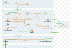
ETL processes in Talend
Spatial ETL processes map geodata and geodata models in the domain of GIS and are a logical step towards the automation and standardization of processes and workflows. In public authorities and companies it is becoming more and more important to structure and provide large amounts of geodata as automated as possible. These so-called data integration solutions can be mapped via spatial ETL processes.
ETL describes the data handling process starting with the loading / merging of different data sources, the data transformation and the output of the data stream. The E stands for Extraction, T for Transformation and L for Load. There are different modeling and ETL tools for geodata, for example FME, GeoKettle or the Spatial Extension from Talend.
ETL describes the data handling process starting with the loading / merging of different data sources, the data transformation and the output of the data stream. The E stands for Extraction, T for Transformation and L for Load. There are different modeling and ETL tools for geodata, for example FME, GeoKettle or the Spatial Extension from Talend.